
Bryan is an avid hiker (so is Justin but he couldn't take any days off that week), so when I heard he was going for THE hike, the Chillkoot Trail, for four days, I couldn't help but to count my lucky stars cause my days off were right where they should be (I had Tuesday, Thursday and Friday off, and Wednesday morning scheduled to work which I found a replacement).
So there I was, on the eve of the hike, barely 12 hours away from the hike, was when I decided. I decided to go for THE hike. The mother of all hikes.
And that decision turned of to be the best one I ever made. Seize the moment, I always say. And that crazy decision gave me a whole lot of wonderful moments...
I paid for the permit on that day itself. Permit to go for the hike.
And the next morning, with nothing packed, I got myself prepared - both mentally and materials-wise (bought food, packed my clothes, but I still think I was unprepared for a lot of other stuff).
I almost brought a blanket for the hike but fortunately (thank God) I bumped into Greg just half an hour before we were to leave to Dyea (the trailhead). He lent me his sleeping bag. It was a bitch to carry but it must have probably saved my life. I could have froze to death... lol...
Everything didn't start off well either. Firstly, the ranger at the trail centre had told us earlier to leave no later than 1pm to reach our first campsite (supposedly Sheep Camp) but because the others (cept for Bryan and me) were no prepared, we had to wait and we left at 5.30pm!!!
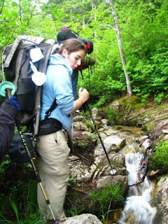
So there we were, Davin, Becca, Geena, Bryan and me, about to go embark on the greatest adventure of our lives, all 53 km or 33 miles of it:
 On the van to Dyea:
 Trailhead: Dyea. This was where we started:
 Signed our names:
 Greg's huge sleeping bag:
 Bryan's filter kicks ass:
 The slower half of the group: Becca, Gee and Davin (Bryan and I left them to hike at their own pace during most of the hikes):
 According to hikers who hiked this part the day before, the water level of the swamp went past the platforms and above thier knees, they had to hike with their footwear off!:
 So Bryan and I left the other three so that we could try to hike faster to our intended campsite, Pleasant Camp, so that we could set up tent before it got dark.
And along the way, we found all these antique stuff left behind during the 1900s all throughout the trail: 
 First stop was Fineggan's Point (around 3.3 miles from the start):
 We left there after a quick stop.
 First stop was Fineggan's Point (around 3.3 miles from the start):
 We left there after a quick stop.
Waterfalls along the way:


 It was almost 8pm. But we're in Alaska, it doesn't get dark till its 11pm.
 Next break, Canyon City:
 I was already having blisters on my feet (damn Army boots); Bryan helped me to bandage it up:
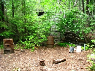
 We took a detour to Canyon City Ruins:
 Old stove:
 Some old tramway:
 Almost 10pm... getting darker...:
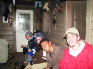
 Bryan and I got to our campsite, Pleasant Camp, at 11pm. It was already so dark and we couldn't pitch a tent so we slept over in the warming shelter instead. The other three only arrived before 1am... They were hiking in complete darkness.
 Luckily there were no other campers cause by right we were not allowed to sleep overnight in the warming shelter and we should have built our tents... The only other inhabitant was this small mouse which woke me up in the middle of the night snacking on bread crumps on my face!!!
 Cool swinging suspension bridge:


 Saw a squirrel eating a marshmallow:
 Really nice waterfall on the side of a cliff:
 Finally reached the campsite we had originally planned to sleep over in the first night, Sheep Camp:
 Avalanche zones:
 More antiques:

 The trail was hard to miss (or so we thought):
 Red Bull rocks!!!:


 Hit snow a number of times:

 And then came the false trail: Paterson's Trail:

 Geena, "What?"
 Becca, "What???!!!"
 Up we go the wrong trail...
 This was whn it was still okay, and I could take pictures:
 But one hour later, the trail became vertically up-sloped. I had never felt so scared in my entire life. Bryan climbed first, me second. And we were climbing using whatever plants and loose bolders and sand to pull ourselves up.


 By this time, Gee had her blisters badly killing her:
  She was thinking of calling it quits.
  The other three left her and me at the back (I volunteered to stay with her at the back, Army kinda makes you have that mentality, leave no man behind... Guess its not in the American culture to care.... I dunno...)
 Those three way at the front. We kept in touch with walky-talkies:

 Even asked the injured Geena to take my picture... lol:
 Where we hiked from:
 Our biggest obstacle (if you don't include the false trail...); Chillkoot Pass:
 This is called the 'Scales', where the gold prospectors from the 1900s left most of their junk before carring their load up the 'Golden Stairs' to the Chillkoot Pass:


 Then the path through the ridge on the valley is called the 'Golden Stairs':
 That's how it looks like, all 3000 feet:
 Picture is kinda deceiving:
 View from halfway:
 Gee and I caught up with Davin and Becca a quarter of the way up the stairs. Bryan was probably at the summit by then:
 And that was where they decided to cook. On the side of the mountain. It was cold as hell, so I thought, "What the heck, I'm going up myself..."
 View from the top:
 Almost as vertically challenging as the Paterson's Trail, almost as dangerous... but just as scary:
 There was still more to climb after the first 'pseudo' summit we could see from the foot of the climb... much more to climb:
 Just when you thought, you are at the summit, there is more to climb...:
 Much more...:
 Much much more...:
 Till you see a monument:
 Dedicated to the Klondke Gold Rush prospectors who risk, limb and lives to climb up this trail:
 View from the top:
 I was up there, enjoying the moment:
 Beautiful view from the top:
 But it still wasn't the summit:
 Still a climb to the summit:
 Still a long long climb:
 Till there I was, on the summit. Chillkoot Pass; its on the US-Canadian boundary:
 Bryan who has been waiting for over an hour:
 The Summit:
 So we waited for the other three in the warming shelter for another 2 hours and then we decided to head down to the original campsite where we were supposed to stay, Happy Camp, instead of staying overnight there and probably frezing our butts to death up there.


 It was almost 8pm. But we're in Alaska, it doesn't get dark till its 11pm.
 Next break, Canyon City:
 I was already having blisters on my feet (damn Army boots); Bryan helped me to bandage it up:
 We took a detour to Canyon City Ruins:
 Old stove:
 Some old tramway:
 Almost 10pm... getting darker...:
 Bryan and I got to our campsite, Pleasant Camp, at 11pm. It was already so dark and we couldn't pitch a tent so we slept over in the warming shelter instead. The other three only arrived before 1am... They were hiking in complete darkness.
The furnace at the warming shelter was so welcoming:
 Luckily there were no other campers cause by right we were not allowed to sleep overnight in the warming shelter and we should have built our tents... The only other inhabitant was this small mouse which woke me up in the middle of the night snacking on bread crumps on my face!!!
Next morning, we woke up late. Again, we were supposed to leave early so that we could reach Chillkoot Pass (and other snow covered parts of the trail) before noon, cause once the sun comes out, the snow will melt and be a bitch to walk on...:
 Cool swinging suspension bridge:

 Saw a squirrel eating a marshmallow:
 Really nice waterfall on the side of a cliff:
 Finally reached the campsite we had originally planned to sleep over in the first night, Sheep Camp:
 Avalanche zones:
 More antiques:
Off we went to Chillkoot Pass:
 The trail was hard to miss (or so we thought):
 Red Bull rocks!!!:

 Hit snow a number of times:
 And then came the false trail: Paterson's Trail:
Bryan, "We have to climb that?"
 Geena, "What?"
 Becca, "What???!!!"
 Up we go the wrong trail...
 This was whn it was still okay, and I could take pictures:
 But one hour later, the trail became vertically up-sloped. I had never felt so scared in my entire life. Bryan climbed first, me second. And we were climbing using whatever plants and loose bolders and sand to pull ourselves up.
It was scary... and when the rock wall was smooth, Bryan used his leg a couple of times to hoist me up. I was trying to use the best of my bouldering and rock-wall climbing skills. And don't forget we were carrying our packs too.
Man, I was so scared...
We thought we could have died up there. When we reached the top (well, at least Bryan and I did), we thought to ourselves, "This can't be it, there are no markers and the trail is hard as hell!"
So we decided to come down (coming down was just as hard, we had to slide on our butts, boulders were rolling everwhere; Bryan almost killed me with one huge one and I had one rolled over my finger, swelling the middle finger) and decide as a group whether to call it quits and go back to Sheep Camp and eventually Dyea or carry on.
We were so demoralized.
When I saw the map, it said to go through the valley instead of up the side of the valley. That's when we decided to try our luck and look for the trail markers, and we saw this: A tiny sign just barely above our knees, "Trail".
 A tiny sign just barely above our knees, "Trail".
We were pissed off:
 So 2 1/2 hours later, we perservered on... It was past noon and we still haven't climbed up to Chillkoot Pass yet. We were so behind time.


 So 2 1/2 hours later, we perservered on... It was past noon and we still haven't climbed up to Chillkoot Pass yet. We were so behind time.


 By this time, Gee had her blisters badly killing her:
  She was thinking of calling it quits.
  The other three left her and me at the back (I volunteered to stay with her at the back, Army kinda makes you have that mentality, leave no man behind... Guess its not in the American culture to care.... I dunno...)
 Those three way at the front. We kept in touch with walky-talkies:
 Even asked the injured Geena to take my picture... lol:
 Where we hiked from:
 Our biggest obstacle (if you don't include the false trail...); Chillkoot Pass:
 This is called the 'Scales', where the gold prospectors from the 1900s left most of their junk before carring their load up the 'Golden Stairs' to the Chillkoot Pass:

 Then the path through the ridge on the valley is called the 'Golden Stairs':
 That's how it looks like, all 3000 feet:
 Picture is kinda deceiving:
 View from halfway:
 Gee and I caught up with Davin and Becca a quarter of the way up the stairs. Bryan was probably at the summit by then:
 And that was where they decided to cook. On the side of the mountain. It was cold as hell, so I thought, "What the heck, I'm going up myself..."
 View from the top:
 Almost as vertically challenging as the Paterson's Trail, almost as dangerous... but just as scary:
 There was still more to climb after the first 'pseudo' summit we could see from the foot of the climb... much more to climb:
 Just when you thought, you are at the summit, there is more to climb...:
 Much more...:
 Much much more...:
 Till you see a monument:
 Dedicated to the Klondke Gold Rush prospectors who risk, limb and lives to climb up this trail:
 View from the top:
 I was up there, enjoying the moment:
 Beautiful view from the top:
 But it still wasn't the summit:
 Still a climb to the summit:
 Still a long long climb:
 Till there I was, on the summit. Chillkoot Pass; its on the US-Canadian boundary:
 Bryan who has been waiting for over an hour:
 The Summit:
 So we waited for the other three in the warming shelter for another 2 hours and then we decided to head down to the original campsite where we were supposed to stay, Happy Camp, instead of staying overnight there and probably frezing our butts to death up there.
The outhouse with a view: Once again, Bryan and I left the group t hike our way down first so that we could set up tent once we reached Happy Camp.
 Once again, Bryan and I left the group t hike our way down first so that we could set up tent once we reached Happy Camp.
Beautiful views along the way down:
 Forget Upper Dewey Lake, this was 10 times larger and more beautiful:

 There were other large frozen lakes too:
 Avalanche zones:
 More scenic views of other frozen lakes; we had to stay close to those orange flag markers:
 Another lake, smaller but just as beautiful:


 Cool waterfall:

 So we hiked till there's not much snow:
 So we hiked to we reached Happy Camp. And boy, were we happy...:
 Bryan and I set up the tent first and the other three came to the site one hour later.

 Forget Upper Dewey Lake, this was 10 times larger and more beautiful:
 There were other large frozen lakes too:
 Avalanche zones:
 More scenic views of other frozen lakes; we had to stay close to those orange flag markers:
 Another lake, smaller but just as beautiful:

 Cool waterfall:
 So we hiked till there's not much snow:
 So we hiked to we reached Happy Camp. And boy, were we happy...:
 Bryan and I set up the tent first and the other three came to the site one hour later.


No comments:
Post a Comment